Eerste beelden klimaatsatelliet PACE vrijgegeven

NASA’s klimaatsatelliet PACE, met aan boord het Nederlandse instrument SPEXone, heeft de mijlpaal van First Light bereikt. Daarmee heeft de wereld nu toegang tot satellietbeelden die type en grootte van fijnstofdeeltjes onderscheiden. SPEXone meet ook de mate waarin aerosolen zonlicht absorberen en reflecteren. Hiermee kunnen wetenschappers de onzekerheden in klimaatmodellen verkleinen. SPEXone is gebouwd door SRON en Airbus Netherlands B.V., met ondersteuning van TNO.

Sinds de lancering op 8 februari 2024 vanaf NASA’s Kennedy Space Center in Florida is PACE zorgvuldig aangezet om te checken of alle instrumenten de heftige schokken en blootstelling aan de ruimte goed hebben doorstaan. Dat resulteert nu in de eerste wetenschappelijke afbeeldingen—First Light. ‘Uiteindelijk gaan heel veel van dit soort metingen optellen tot een compleet beeld van aerosolen in de atmosfeer,’ zegt Otto Hasekamp (SRON), hoofdonderzoeker van SPEXone. ‘We brengen in kaart hoeveel van welke soort fijnstof er is, en gaan die informatie combineren met klimaatmodellen om te onderzoeken wat hun bijdrage is aan de wereldwijde temperatuur. Dan weten we beter in welke mate fijnstof de opwarming door broeikasgassen maskeert.’


Figuur 1: Wereldkaart in gepolariseerd licht, opgebouwd uit de 100-km brede stroken die SPEXone over de aarde trekt. Credit: SRON

‘SPEXone werkt precies zoals we bedacht en ontworpen hebben en gedraagt zich net als bij de laatste testen op de grond,’ zegt Marc Oort, systems architect bij Airbus. ‘Het zorgvuldige ontwerp en nauwgezette samenbouw hebben hun nut bewezen. SPEXone is klaar voor zijn belangrijke taak.’

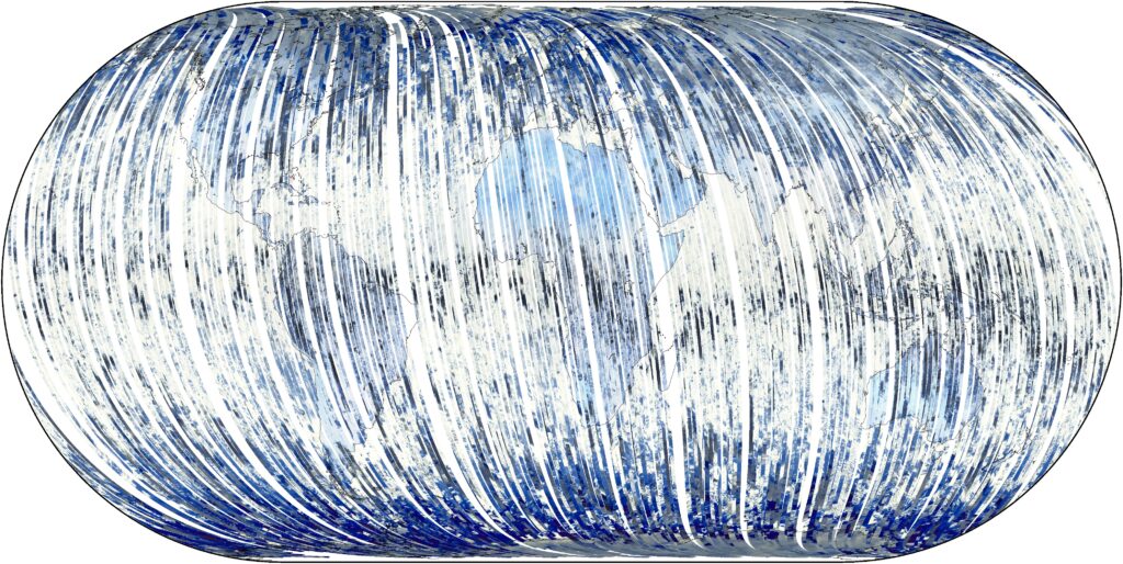
Figuur 1 toont de wereld bezien vanachter een polaroid zonnebril, gecompileerd door de honderden banen van SPEXone om de aarde. Daarbij trekt het instrument als een bezem een 100-km brede strook over de aarde in de zuid-noordrichting. Verschillende achtergronden zoals zee en land polariseren zonlicht op hun eigen manier, waardoor ze er anders uitzien. Land is bijvoorbeeld vaak blauw, omdat alleen het verstrooide licht in de lucht erboven is gepolariseerd.


Figuur 2: SPEXone werpt haar 100-km brede blikveld over Japan (links) en Ethiopië (rechts). Het instrument meet voor verschillende kleuren in welke mate het zonlicht wordt gepolariseerd, vanuit vijf verschillende kijkhoeken. Credit: SRON

Figuur 2 bevat een baan van SPEXone over Japan en Ethiopië. De rest van het plaatje is gemaakt door het OCI-instrument, ook aan boord van PACE. Wolken zijn zwart omdat ze geen enkele kleur polariseren. Aerosolen polariseren alle kleuren zonlicht, waardoor ze zichzelf verraden. Na analyse van deze polarisatiedata brengt het SPEXone-team vervolgens de eigenschappen van de aerosolen in kaart, zoals weergegeven in figuur 3.


Figuur 3: De conclusies uit de polarisatiemetingen boven Japan (links) en Ethiopië (rechts). De panelen tonen de hoeveelheid fijne deeltjes, grove deeltjes en mate van absorptie. Credit: SRON

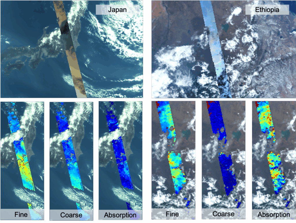
Figuur 3 toont de eigenschappen van aerosolen boven Japan (links) en Ethiopië (rechts). Beide bestaan voornamelijk uit fijne deeltjes. Beide linkerpanelen tonen immers veel rode en gele plekken, terwijl de middenpanelen grotendeels blauw zijn. In het rechterpanel zien we dat het fijnstof boven Ethiopië veel zonlicht absorbeert; het heeft de signatuur van rook door de verbranding van biomassa. Boven Japan zien we veel fijnstof rond Tokio, richting het zuiden geblazen door de wind. Daar toont het rechterpanel de signatuur van een mix van aerosol uit industrie en transport en natuurlijk fijnstof zoals zeezout.

Jeroen Rietjens (SRON) zat achter de knoppen in de control room op NASA’s Goddard Space Flight Center toen de eerste data binnenkwamen. ‘Toen we het commando gaven om SPEXone aan te zetten, was het een enorme opluchting om ons instrument in goede gezondheid te zien. We waren helemaal blij toen we twee weken later de eerste camerabeelden namen en het lukte om er fijnstofkaarten van te maken. Dat betekende dat alle schakeltjes samenvielen waar we met zijn allen jaren aan hadden gewerkt.’


SPEXone is ontwikkeld door een Nederlands consortium bestaande uit SRON en Airbus Netherlands B.V., daarbij ondersteund door TNO. SRON en Airbus zijn verantwoordelijk voor het ontwerp, de assemblage en het testen van het instrument. De wetenschappelijke leiding ligt in handen van SRON. SPEXone is een publiek-privaat initiatief dat mogelijk gemaakt is door het NSO met door OCW beschikbaar gestelde middelen en door SRON/NWO-I en ondersteund door private investeringen van Airbus Netherlands B.V.

PACE climate satellite releases first images

NASA’s PACE climate satellite, with onboard the Dutch instrument SPEXone, has reached the First Light milestone. The world now has access to satellite images distinguishing types and sizes of aerosols. SPEXone also measures the extent to which aerosols absorb and reflect sunlight. This allows scientists to reduce uncertainties in climate models. SPEXone was built by SRON and Airbus Netherlands B.V., with support from TNO.

Since its launch on February 8, 2024 from NASA’s Kennedy Space Center in Florida, PACE has been carefully powered on to ensure all instruments have withstood the severe shocks and exposure to space. This now results in the first scientific images—First Light. ‘Eventually, many of these measurements will add up to a complete picture of aerosols in the atmosphere,’ says Otto Hasekamp (SRON), SPEXone principal investigator. ‘We map per area how much of each aerosol type there is, and combine that information with climate models to calculate their contribution to global temperatures. Then we will know better to what extent aerosols are masking global warming caused by greenhouse gases.’


Figure 1: World map in polarized light, compiled from 100-km wide strips that are drawn by SPEXone in its orbit around the Earth. Credit: SRON

‘SPEXone works exactly as we conceived and designed and it behaves just like in the latest tests on the ground,’ says Marc Oort, systems architect at Airbus. ‘SPEXone is ready for its important task.’

Figure 1 shows the world as seen from behind polaroid sunglasses, compiled from SPEXone’s hundreds of orbits around the Earth. The instrument draws a 100-km wide strip across the Earth, like a push broom, in the south-north direction. Different backgrounds such as ocean and land polarize sunlight in their own way, making them look different. For example, land is often blue because only the scattered light in the sky above is polarized.


Figure 2: SPEXone casts its 100-km wide field of view over Japan (left) and Ethiopia (right). The instrument measures to what extent sunlight is polarized for multiple colors, from five different viewing angles. Credit: SRON

Figure 2 contains a SPEXone trajectory over Japan and Ethiopia. The rest of the picture was created by the OCI instrument, also onboard PACE. Clouds are black because they don’t polarize any color. Aerosols reveal themselves by polarizing all colors of sunlight. After analyzing this polarization data, the SPEXone team maps the properties of the aerosols, as shown in Figure 3.


Figure 3: The conclusions from the polarization measurements above Japan (left) and Ethiopia (right). The panels show the amount of fine particles, coarse particles and the amount of absorption. Credit: SRON

Figure 3 shows the properties of aerosols over Japan (left) and Ethiopia (right). Both consist mainly of fine particles. Both left panels show many red and yellow spots, while the middle panels are largely blue. In the right panel we see that the aerosols above Ethiopia absorb lots of sunlight; it has the signature of smoke from the combustion of biomass. Above Japan we see a lot of aerosols around Tokyo blown southwards. The right panel shows the signature of a mix of urban pollution and natural aerosols such as sea spray.

Jeroen Rietjens (SRON) was working in the control room at NASA’s Goddard Space Flight Center while the first data came in. ‘After we entered the command to turn on SPEXone, it was a huge relief to see our instrument in good health. Two weeks later we were even happier when we took the first camera images and managed to create aerosol maps. It was the culmination of years of hard work of the entire team.’


SPEXone was developed by a Dutch consortium consisting of SRON and Airbus Netherlands B.V., with support from TNO. SRON and Airbus are responsible for the design, assembly and testing of the instrument. The scientific leadership is in the hands of SRON. SPEXone is a public-private initiative made possible by NSO with resources made available by OCW and by SRON/NWO-I and supported by private investments from Airbus Netherlands B.V.