



The TROPOMI satellite instrument detects thousands of large methane plumes a year, but some of those plumes stand out. This weekend, we received an alert that our automated plume detection algorithm spotted a large methane plume in an oil field in Niger in observations from October 8.
Analysis of Sentinel-2 data
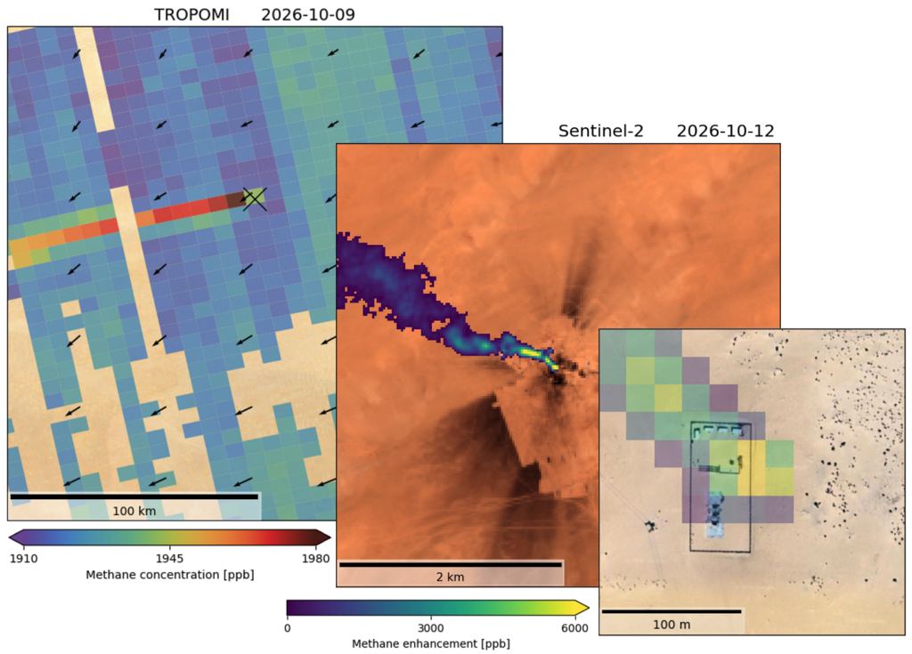
This is not an area where we see a lot of plumes so team members followed up by analyzing high-resolution Sentinel-2 data to find out an oil well was the culprit. This site showed large methane plumes in Sentinel-2 observations and a large black stain visible around the site indicated an incident could have happened in the days before. Further analyzing available satellite data, the team was able to pinpoint the start of the event to September 25 and as of today, all subsequent observations have shown large emissions (~40 tons of methane per hour).

SRON notified Copernicus Atmospheric Monitoring Service
On Sunday (11 Oct.), SRON communicated the plume to the Copernicus Atmospheric Monitoring Service (whose Methane Hot Spot Explorer features all our TROPOMI detections), notified the International Methane Emissions Observatory to enable them to contact the responsible parties, and reached out to satellite partners to acquire additional observations of the event.
Exceptional environmental incident
Yesterday (13 Oct.), an article in Le Monde brought more insight into what happened, describing an explosion causing an exceptional environmental incident at the Goumeri W8 well on the Agadem oil block. Today (14 Oct.), CAMS communicated first results of the ongoing monitoring. We will keep working with our partners to bring together all available satellite insights to optimally monitor events like these and support their mitigation. The image shows a TROPOMI plume from October 9 as well as a Sentinel-2 methane plume detection from October 12 over visual imagery from the same day, showing a (partly cleaned up) black stain around the site. The inset zooms in on the origin of the Sentinel-2 plume over archive Google Maps imagery showing the facility.